CloudRoots methodological approach is based on developing and using multiple observations and modelling approaches to bridge the gap between scales and unravel the links between the biochemical and physical processes (see SCALES and DISCIPLINES). In measuring, the main novelty is to be able to observed the links between the rapid surface turbulent fluxes (1-minute) perturbed by clouds and turbulence. In simulating, we attempt to resolve explicitly the evolution of the main processes to infer generic cross-scale relationships. By integrating observations and numerical experiments, we will improve our understanding of the transient exchange of energy, water and carbon from the leaf to the boundary layer over heterogeneous surfaces.
OBSERVATIONS
In addition of the standard turbulent and meteorological observations, CloudRoots will test the innovating technique to combine stable isotopologues measured at a high-flow rate with the scintillometer technique. This measurements will be supported by ecophysiology measurements. The main goal is to observe 1-minutefluex of the isofluxes to calculate the partitioning of water and carbon fluxes during transitional situations dominated by clouds.
ECOPHYSIOLOGICAL
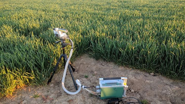
Ecophysiological measurements are conducted with the LI-COR LI-6400XT portable photosynthesis system. The LI-6400XT is capable of measuring leaf gas exchange while adjusting and controlling light, temperature, humidity and CO2 concentrations experienced by the plant leaf. The system is generally used to measure key photosynthesis parameters such as instantaneous photosynthesis and transpiration, stomatal conductance and maximum rates of carboxylation and electron transport. Other experiments are conducted to establish light, CO2 and temperature response curves as well as the rate at which stomatal conductance adjust to changes in light intensity.

TURBULENCE-SCINTILLOMETER
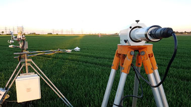
The shimmer in the air often seen above a hot road is one example of a scintillation. This optical effect is brought about by turbulent eddies that transport heat and water vapor causing fluctuations in the refractive index of air which results in the random bending and focusing/defocusing of light rays. A scintillometer is a horizontal probing remote sensing instrument that consists of a transmitter and receiver that measures the intensity of the scintillation effects and relates that back to the fluxes that causes them. Different types of scintillometers exist based on the different wavelengths used and the different aperture diameters needed which affects the path length over which the scintillometers can be operated.
We will use a short-path (~100m) laser scintillometer. The added value of this scintillometer over the more traditional Eddy Covariance (EC) method is that the scintillometer converges to statistically stable flux estimates at much shorter flux averaging times of 1 minute or less (see CANOPY), while the EC technique typically requires flux averaging times of 10 to 30-minutes.
Short-path scintillometer and eddy-covariance system

STABLE ISOTOPOLOGUES
Isotopologues are molecules containing one or multiple rare isotope(s). For the CloudRoots project, the main isotopologues of CO2 and H2O will be measured and modeled. Combining both methods will enable us to differentiate whether the soil or the vegetation are the source of a water vapor or the carbon dioxide fluxes. As isotopologues contain rare isotopes, their abundance is low, which makes them difficult to measure. In the CloudRoots project we will use state-of-the-art closed path laser spectrometers to measure isotopologue concentrations in the field. Such a device uses the absorption of laser light at certain frequencies to measure the concentration of specific isotopologues. To this end, we use an Aerodyne TILDAS-CS to observe 12CO2, 13CO2, C17OO and C18OO, and a Picarro L2030i (flight modified) for measuring H216O, DHO and H218O. The laser spectrometers allow for high frequency measurements at 10Hz and 5Hz respectively. Our goal is to couple these high frequency isotope data to turbulence measurements using an Eddy covariance system or a Scintillometer in order to derive field-scale isofluxes.
MODELING
We plan to use a hierarchy of models ranging from leaf to regional scales. These techniques go from explicit ideal to realistic numerical experiments perfmed by DALES, conceptual modelling (CLASS) to support observations and regional modelling to cover the three ecosystems under study.
REGIONAL
To expand our understanding to the regional level in the Amazonian basin, Western Europe, and Scandinavia, we plan to embed the DALES simulation model within the global model ECMWF-IFS. The embedding of DALES in a global model characterized with high-spatial horizontal resolution (between 9 to 25 km x km) allows us to merge the benefits of both modelling approaches: (1) explicit simulations of the interaction between vegetation and clouds by DALES that (2) take into account the accurate boundary and initial conditions calculated by ECMWF-IFS.
CONCEPTUAL
CLASS (Chemistry Land surface Atmosphere Soil Slab) combines the theoretical concepts of the land-atmosphere-cloud system outlined in a course book with the CLASS software. This software provides hands-on practical exercises and allows a researcher or student to design their own numerical experiments. CLASS is an ideal modelling tool to support the observational analyses of biological, chemical, soil, plant and atmospheric boundary layer dynamics. In addition to the original friendly graphical interface, there is a version coded in PYTHON and FORTRAN.
More information and the code at http://classmodel.github.io/
TURBULENCE
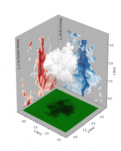
DALES (Dutch Atmospheric Large Eddy Simulation) is a large-eddy simulation code that is able to reproduce unstable, neutral and stable stratified clear and cloudy boundary layers. It integrates biology (photosynthesis, soil respiration), chemistry (NOx-VOC-O3), radiative transfer, microphysics, canopy effects and large-scale forcing in the explicit solution of the most energetic eddies and clouds. The code has been applied to academic or idealized flows as well as to reproduced observations taken in boreal forests, grasslands and the Amazon basin.
More information and the code
DALES three-dimensional snapshot of a cloud interacting with the surface: vertical velocity (left side panel red) and moisture flux (right side panel in blue)


